
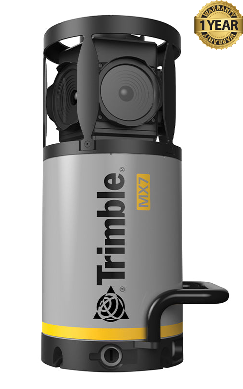


Trimble MX7 360 Mobile Imaging System
Condition: Refurbished / Calibrated
Warranty: 1 YEAR WARRANTY
Shipping: USA & Worldwide
|
* Trimble MX7 360 Mobile Imaging System (BC# -L/T*) |
Trimble MX7 360 Mobile Imaging System
The Trimble MX7 is a vehicle-mounted mobile imaging system used to document roads, buildings, and other infrastructure. As the vehicle travels, the MX7 captures panoramic images of its surroundings. It gives surveyors and asset managers a visual record of a route without requiring them to photograph each location individually.
Six cameras work together to produce 30-megapixel, 360-degree images. The system can collect images while the vehicle is moving at highway speeds, allowing crews to cover long roads or large project areas efficiently. The resulting imagery lets users revisit locations from the office and examine features from multiple viewpoints.
The MX7 combines its cameras with GNSS and inertial positioning technology. This records where the vehicle was and how the cameras were oriented when each image was taken. The images can then be tied to geographic locations, making it easier to find a particular road segment, structure, or asset later.
In the office, users can review the imagery, identify features, add information to asset records, and make measurements from the images using compatible processing software. Typical applications include road and highway inventories, inspections of bridges and buildings, utility planning, and documentation of conditions before or after construction.
The MX7 is primarily an imaging system: it collects georeferenced photographs rather than the laser-scanned point clouds produced by some other mobile mapping systems. Its main benefit is that teams can capture a broad visual record during one drive and use that record for mapping, measurement, and planning afterward.
Features:
- Six 5-megapixel cameras that combine to produce 30-megapixel panoramic images.
- 360-degree imagery covering approximately 90% of the full sphere.
- Vehicle-mounted capture for documenting roads and sites while driving, including at highway speeds.
- Built-in GNSS and inertial positioning to record the location and orientation of each image.
- Georeferenced images that can be found and reviewed by location.
- Mobile and stationary capture modes for different site conditions.
- Office measurement and feature extraction using compatible Trimble software.
- Compact, roof-mounted design that can be installed on a suitable vehicle.
| Specification | Trimble MX7 |
|---|---|
| Image resolution | 30 MP total; six 5 MP CMOS sensors |
| Image coverage | 90% of a full sphere |
| Calibrated imaging distance | 2 m to infinity |
| Operating modes | Stationary or vehicle-mounted mobile capture |
| Images | 360° georeferenced panoramas |
| System | Trimble AP15 GNSS-inertial system |
| Integration technology | Applanix IN-Fusion |
| GNSS channels | 220 |
| Inertial measurement unit | Applanix IMU-69, 200 Hz |
| Typical post-processed position error, no GNSS outage | 0.02–0.05 m |
| Typical post-processed position error, 1 km or 1-minute GNSS outage | 0.2–0.8 m |
| Typical post-processed heading error, no GNSS outage | 0.08° |
| Typical post-processed heading error, 1 km or 1-minute GNSS outage | 0.2° |
| Sensor head weight | 11.3 kg |
| Data storage | 2 TB SSD |
| Supply | 12–24 V DC; typically 100 W |
| Operating temperature | 0°C to +35°C |
| Sensor head protection | IP65 |
| Power box protection | IP20 |
| Positioning | Distance measurement indicator (DMI) |
| Orientation | GNSS Azimuth Measurement System (GAMS) |