
Trimble Mensi GS200 Spatial Scanner 3D Laser Scanning System
Trimble GS200 3D Laser Scanning System Version 3.2.4.0 w/ Tripod & Trimble PointScape 3.2 Software
$0.01
Availability:
Out of stock
SKU
XPSC03
Condition: Refurbished
Warranty: 1 YEAR WARRANTY
Shipping: USA & Worldwide
Request a Quote for
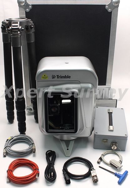
* Trimble Mensi GS200 Spatial Scanner 3D Laser System [ID- X1078]
* Trimble GS Mensi Power Box
* RJ45 To RJ45 Cable
* 25 Pin Cable P/N: DOC68
* Hi-Flex-Cy Cable P/N: A6-542
* Cebec Kema-Keur 360.75mm2 Cable
* Trimble Pointscape 3.2 Software
* Tripod
* Allen Wrench
* Protective Cover
* Power Cord
* Hard Carrying Case
Trimble GS200 3D Laser Scanner
BROADER BUSINESS OPPORTUNITIES
The Trimble® GS Series™ 3D Scanner captures coordinates and texture data through leading edge technology and unique features, creating opportunities for surveying activities not possible with traditional methods or low performance scanners. The GS Series offers
extreme versatility to meet the challenges of many existing and new market opportunities. It guarantees data sets that underpin advanced and compelling deliverables via Trimble’s 3D data-editing office software.
UNIQUE, POWERFUL FEATURES
Some of the powerful features offered by the GS Series include motorized indoor and outdoor scanning through 360°, and optimized performance up to 200 m (Trimble GS200™).Trimble’s unique OverScan™ technology enables data capture up to 350 m (Trimble GS200).
On-board video technology provides real-time true-color acquisition, panoramic snapshot capability for enhanced scene framing, and multiple zoom factors for high-resolution image acquisition.
INCREASED PRODUCTIVITY
The GS Series’ accuracy and speed, along with flexible automatic or user-definable scan parameters, can save up to 80% of time and labor resources in many surveying applications, particularly when combined with Trimble’s 3D data-editing office software. With the GS Series’ top adaptor, experience Trimble’s Integrated Surveying solution, which combines scanning, GPS, and optical total station data for exceptional efficiency in the field and office.
Because it is compact and lightweight with fast set-up, the GS Series is extremely maneuverable in the field. One-person operation is possible, which saves labor costs even further.
The system is also WiFi-ready, and can be controlled by the Trimble Recon™ controller running the Microsoft® Pocket PC operating system. Run Trimble data collection software together with any other Pocket PC applications designed to enhance your business.
FAST RETURN ON INVESTMENT
The Trimble GS Series 3D Scanner is ideal for everyday use in a variety of applications, so you can achieve return on your investment quickly.
Further ensure your rate of return with industry-leading on-board intelligence. It offers enhanced data pre-processing, customizable parameter setting, auto-focus management, and dynamic filtering. And stay up-to-date on these and other functionalities with regular high-level firmware upgrades.
Specifications:
| GENERAL |
||||||
| Instrument type |
Long-range
laser mapping system |
|||||
| Metrology method | Time of flight | |||||
| User interface | Trimble Recon, Notebook PC | |||||
| Data interface |
Network TCP/IP, Wireless WiFi (optional) | |||||
| SYSTEM PERFORMANCE | ||||||
| Addressability | 700 m (400 m) | |||||
| Range using OverScan | 2–350 m (200 m) | |||||
| Standard range | 2–200 m (100 m) | |||||
| Scanning speed | up to 5000 points per second | |||||
| Standard deviation | ||||||
| Range (m) | 5 |
25 | 50 | 100 |
150 |
200 |
| Typical values (mm) |
1.4 | 1.4 | 1.4 | 2.5 | 3.6 | 6.5 |
| Multishot | yes: user-definable number of shots per point | |||||
| Minimum resolution |
3 mm @ 100 m (32 µrad) | |||||
| Field of
view |
||||||
| Horizontal | 360° | |||||
| Vertical | 60° (angle included) | |||||
| Laser type |
pulsed |
|||||
| Laser color | green | |||||
| Safety | Class 2 (21 CFR §1041.10) / Class 3R (IEC 60825-1) | |||||
| Laser beam diameter |
3 mm @ 50 m | |||||
| Autofocus | Yes | |||||
| On-board video | 768 × 576 color resolution real-time video transmission | |||||
| Video zoom factor | up to 5.5 times | |||||
| Video snapshot | yes: automatic picture mosaic 9 megapixels max. resolution | |||||
| Point capture modes | X Y Z X Y Z, point orientation X Y Z, returned intensity (8 bits – 256 grayscale) X Y Z, RGB true color (8 bits per channel) X Y Z, orientation, returned intensity, RGB true color |
|||||
| Geo-referencing |
yes: using standard surveying tripod | |||||
| PHYSICAL |
||||||
| Scanner |
||||||
| Dimensions | 340 mm D × 270 mm W × 420 mm H including handles | |||||
| Weight | 13.6 kg (29.9 lb) | |||||
| Power Supply Unit | ||||||
| Dimensions |
105 mm D × 200 mm W × 65 mm H | |||||
| Weight | 1.5 kg (3.3 lb) | |||||
| Transportation Box | ||||||
| Dimensions | 645 mm D × 490 mm W × 435 mm H (airline checkable) | |||||
| Weight | 12.8 kg (28.2 lb) | |||||
| Environmental | ||||||
| Operating temperature | 0 °C to 40 °C | |||||
| Storage temperature | –20 °C to 50 °C | |||||
| Sealing |
IP53 |
|||||
| Shock | 2M2 / M3 transportation standard compliant | |||||
| Humidity | non-condensing atmosphere | |||||
| Electrical |
||||||
| Power supply | AC 90 V AC–240 V AC, 50 Hz–60 Hz DC 24 V, nominal | |||||
| Manufacturer | Trimble |
|---|