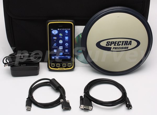


Spectra Precision Pro Mark 700 Network RTK Rover w/ Trimble JUNO T41 / 5B
Condition: Refurbished
Warranty: 1 YEAR WARRANTY
Shipping: USA & Worldwide
- Serviced By A Spectra Authorized Service Center
* Trimble JUNO T41 / 5B Data Collector [ID - X1891]
- SurvCE Version 5.02 Software
- TS
- GPS
- Robotics
- Roads
* Spectra Precision Programming Cable P/N: 90575
* Trimble USB Power Cable
* AC Adapter/Charger
* User Manual On Cd-ROM
* Carrying Case (G)
Spectra Precision Pro Mark 700
The Perfect Network RTK Rover:
Lightweight, Rugged and Simply Reliable
ProMark 700
The Spectra Precision ProMark™ 700 GNSS receiver is the lightest
network RTK rover on the market today. Very compact, slim and
cable-free, ProMark 700 is portable, ergonomic and comfortable for
all-day use in the field. Its long-lasting battery allows all-day
operations without any need for battery recharging or replacement. And,
thanks to the extremely rugged, shock-proof and waterproof design,
ProMark 700 withstands the most extreme outdoor conditions.
ProMark 700 provides all the necessary features for effective network
RTK operations, without the unnecessary complexity of rarelyused
modules and options. The dualfrequency, dual-constellation GNSS
receiver has 220 channels to ensure that all available satellite
signals are tracked. Together with a choice of rugged data collectors
and productive field software – Survey Pro or FAST Survey – ProMark 700
creates a perfect network RTK solution.
The lightest RTK rover on the market
- RTK network rover with 220 channels
- Extremely light and compact
- Reliable and proven technology
Built for the field
- Ultra-rugged and shock resistant design
- Truly waterproof and dust-proof
- All-day battery life
Easy-to-use, easy-to-own
- Ready-to-use configuration
- Ergonomic operation in the field
- Simple and affordable solution
Choice of Data Collectors
Pair the ProMark 700 receiver with a choice of data collectors, field
and office software to create a robust, ready-to-use, cable-free RTK
solution. With such features as large color touch screens, SDHC memory
slots, cellular modems, WLAN and Bluetooth™ wireless technologies, you
can choose from among the following data collectors:
- The MM10 Data Collector: A very lightweight but rugged design, with extremely long battery life (over 20 hours) making it a perfect tool for long surveying jobs
- The T41™ Data Collector: A rugged, connected, slim and compact handheld, offering class-leading performance with a high-resolution outdoor readable display
- The Ranger™ 3 Data Collector: An ultra-rugged field terminal with full alphanumeric keyboard, for use in tough outdoor environments
- The ProMark™ 100 Data Collector: A rugged GNSS handheld that can also be used for additional work such as pre-survey and GIS data collection
Survey Pro Field Software
Survey Pro field software provides you with a complete set of
capabilities for all your survey projects. It’s fast, reliable and easy
to use. It provides unparalleled integration, data integrity, and
efficiency. Survey Pro software is offered in a variety of modules to
best fit the job, and features can be added as needed. Survey Pro is
unmatched in its capabilities and is one of the reasons it has been a
top choice of surveyors for more than 20 years.
FAST Survey Field Software
Advanced FAST Survey field software meets the most demanding survey
requirements. It includes topographic features typically associated
with dual-frequency GNSS surveying, and provides extensive data formats
and local coordinate system support. Added options make it possible to
interact with a wide range of survey instruments and accessories to run
complete survey jobs, including site calibration, stake out, and survey
projects where total stations are used.
Specifications:
| GNSS Characteristics | ■ 220 GNSS channels - GPS L1C/A,
L2P and L2C - GLONASS L1C/A and L2C/A - SBAS: code and carrier
(WAAS/EGNOS/ MSAS/GAGAN) ■ Very low noise GNSS carrier phase measurements ■ Proven low elevation tracking technology ■ Up to 5 Hz real-time position output ■ Supported data formats: RTCM 2.0, 2.1, 2.3, 3.0 and 3.1, CMR, CMR+ ■ RTK networks: VRS, FKP, MAC |
| Real-Time Accuracy (RMS) | |
| SBAS (WAAS/EGNOS/MSAS/GAGAN) | ■ Horizontal < 50 cm (1.64
ft) ■ Vertical < 85 cm (2.79 ft) |
| Real-Time DGPS position | ■ Horizontal 25 cm (0.82 ft) + 1
ppm ■ Vertical 50 cm (1.64 ft) + 1 ppm |
| Real-Time Kinematic position (fine mode) (< 30 km baseline) | ■ Horizontal 10 mm (0.033 ft) +
1 ppm ■ Vertical 20 mm (0.065 ft) + 1 ppm |
| Real-Time Performance | ■ Initialization time: typically
< 10 sec (for baselines < 20 km) ■ Initialization reliability: > 99.9% |
| Post-Processing Accuracy (RMS) 1 | |
| Static, Rapid Static | ■ Horizontal 5 mm (0.016 ft) +
0.5 ppm ■ Vertical 10 mm (0.033 ft) + 0.5 ppm |
| High-Precision Static | ■ Horizontal 3 mm (0.009 ft) +
0.5 ppm ■ Vertical 6 mm (0.019 ft) + 0.5 ppm |
| Post-Processed Kinematic | ■ Horizontal 10 mm (0.033 ft) +
1 ppm ■ Vertical 20 mm (0.065 ft) + 1 ppm |
| Data logging Characteristics | |
| Recording Interval | ■ 1 - 60 seconds |
| Physical Characteristics | |
| Size | ■ Unit: 20.5x20.5x6.2 cm (8.1x8.1x2.4 in) |
| Weight | ■ GNSS receiver: 650 g (1.4 lb) |
| I/O Interface | ■ 9-16 V DC input power ■ RS232 serial link ■ Bluetooth 2.0 class 2 (SPP profile) |
| Memory | ■ 6 MB internal memory
(expandable through data collector memory) ■ Up to 100 hours of 15 sec. raw GNSS data from 18 satellites |
| Operation | ■ RTK network rover: VRS, FKP,
MAC ■ Point-to-point through Real-Time Data Server (RTDS) software ■ NTRIP, Direct IP |
| Environmental Characteristics | ■ Operating temperature: -30° to
+65°C (-22° to +149°F) 4 ■ Storage temperature: -40° to +70°C (-40° to +158°F) ■ Humidity: 100% condensing ■ IP67 waterproof, sealed against sand and dust ■ Shock: ETS300 019 ■ Drop: 2 m pole drop on concrete |
| Power Characteristics | ■ Li-Ion battery, 5000 mAh ■ Battery life time: 10 hrs ■ Nominal voltage: 3.7 V ■ External DC power: 9-16 V with reverse polarity protection (ISO 7637) |
| Standard System Components | ■ ProMark 700 receiver ■ Power cable ■ AC/DC adaptor ■ CLA adaptor ■ Soft bag |
Trimble Juno 5 Series Data Collector
WORK SMART WITH SMARTPHONE-INSPIRED MOBILE GIS
Your team will perform better when they’ve got the tools they need to
get the job done. Trimble® Juno® 5 series handhelds combine must have
functionality with the familiarity of a smartphone form-factor.
Compatible with GIS-oriented Trimble workflows, the Juno 5 is the smart
solution your team can trust for standardizing inspections and asset
management.
Bringing GIS out to the field
Perfect for asset management and data maintenance projects, everything
is integrated into a convenient, rugged package: highsensitivity GNSS,
Windows® Embedded Handheld operating system, Office applications,
camera, and cellular connectivity.
Stay flexible and connected with the optional built-in communications
to send and receive calls and data on the job, keeping your team
productive, informed, and in touch.
Using the professional workflows of Trimble field and office software,
you can work with confidence in the data you are capturing.
A smarter approach to field
productivity
It may look like a smartphone, but the Juno 5 series is all business.
Rugged enough to meet military specs, with an IP68 rating. It has a
large screen so you can easily view data or photos even in direct
sunlight.
You can be confident that your teams have a real, professional
tool—built to work in even the toughest conditions.
Options for flexibility
With enhanced GPS in real time and 1D or 2D barcode options to choose
from the Juno 5 series can meet whatever your workflow needs.
The Trimble Juno 5 combines the convenience of a smartphone with
professional rugged design, for true confidence in the field. This
makes the Trimble Juno 5 series the tool of choice for flexible, real
world asset management and GIS data updates.
Features:
- Familiar, easy-to-use, smartphone form factor
- Works with professional software for GIS workflows
- Big, sunlight-readable screen
- Stay in touch with the office— integrated communications available
- Rugged for work in all conditions
- 1D/2D barcode scanner and enhanced GPS versions available
Specifications:
| STANDARD FEATURES | |
| System | • Integrated 3.75G cellular
data, text, and voice capability (Juno 5D only) • 8 megapixel camera with geotagging and dual LED flash • High-sensitivity GPS/SBAS1 receiver and antenna • Bluetooth® version 2.1 with enhanced data rate • Wi-Fi (802.11b/g/n) • Multi-touch 4.3 inch WVGA sunlight-readable Gorilla® glass display • Long-life, rechargeable Li-Ion battery • 800 MHz (Juno 5B) or 1.0 GHz (Juno 5D and Juno 5B/5D with Barcode scanner and Enhanced GPS) OMAP DM3730 • 512 MB RAM • 8 GB (Juno 5B), 16 GB (Juno 5D), or 32 GB (Juno 5B/5D with Barcode scanner and Enhanced GPS) Flash storage • MicroSD memory card slot (supports SDHC up to 32 GB) • Integrated speaker and microphone |
| Operating System | Windows Embedded Handheld 6.5 in Chinese (Simplified), English, French, German, Italian, Japanese, Korean, Portuguese (Brazilian), Russian, or Spanish |
| Barcode scanner | 1D
symbologies: EAN/UPC, GS1 Databar (limited expanded &
omni-directional), Code 39, Code 128, UCC/EAN 128, ISBN, ISBT,
Interleaved/Matrix/ Industrial and Standard 2 of 5, Codabar, Code
93/93i, Code 11, MSI, Plessey, Telepen, postal codes (Australian Post,
BPO, Canada Post, Dutch Post, Japan Post, PostNet, Sweden Post) 2D symbologies: Data Matrix, PDF417, Micro PDF 417, Codablock, Maxicode, QR, Aztec |
| TECHNICAL SPECIFICATIONS | |
| Physical | |
| Size (5B/5D) | 15.5 cm x 8.2 cm x 2.5 cm (6.1 in × 3.2 in × .9 in) |
| Weight including battery | Juno 5. . . . . . . . . . . . .
. . . . . . . . . . . . . . . . . . . . . . . . . . . . . . . . . . . .
. . . . . . . . . . . 0.4 kg (0.84 lb) Juno 5 with Barcode. . . . . . . . . . . . . . . . . . . . . . . . . . . . . . . . . . . . . . . . . . . . . . 0.50 kg (1.10 lb) Juno 5 with Enhanced GPS. . . . . . . . . . . . . . . . . . . . . . . . . . . . . . . . . . . . . . . . 0.45 kg (0.99 lb) Juno 5 with Enhanced GPS and Barcode. . . . . . . . . . . . . . . . . . . . . . . . . . . . 0.50 kg (1.10 lb) |
| Processor | 800 MHz (5B) or 1.0 GHz (5D and 5B/5D with Barcode scanner, Enhanced GPS) OMAP DM3730 |
| Memory | 8 GB (5B), 16 GB (5D), or 32 GB (5B/5D with Barcode scanner, Enhanced GPS) built in storage, and 512 MB RAM |
| Battery | 12.2 Wh (3.7 V, 3300 mAh) Lithium-ion polymer battery, rechargeable |
| Power | |
| Low (no GPS, backlight on3 | 14 hours |
| Normal (with GPS and backlight on) | . . . . . . . . . . . . . . . . . . . . . . . . . . . . . . . . . . . . . . . . 8 hours |
| Environmental (MIL-STD-810G) | |
| Operating temperatur | –30 °C to +60 °C (–22 °F to +140 °F) |
| Storage temperature | –40 °C to +70 °C (–40 °F to +158 °F) |
| Humidity. | 90% relative humidity with temperatures between |
| Water/dust | Protected against driving rain, water spray, dust, IEC-60529 IP68 |
| Drop | 1.22 m (4 ft.), Method 516.6, Procedure IV, Transit Drop |
| Vibratiom | Vibration resistant, Method 514.6, Procedure I & II, Category 5 |
| Altitude | 4,572 m (15,000 ft) at 23 °C (73 °F) to 12,192 m (40,000 ft) at –30 °C (–22 °F) Method 500.5, Procedure I, II & III |
| Input/output | |
| Expansion | microSD Card slot |
| Display | 10.9 cm (4.3 in) WVGA TFT (480 x 800 pixel), capacitive, sunlight readable |
| Audio | Built-in microphone and speaker, record and playback utilitiea |
| I/O | USB 2.0 Host, USB Client |
| Radios | Bluetooth v2.14 + EDR; Wi-Fi 802.11b/g/n UMTS / HSPA+, GSM / GPRS / EDGE UMTS Bands (WCDMA/FDD): 800/850/1900, AWS and 2100 MHz GSM Bands: 850/900/1800/1900 MHz (data and voice, Juno 5D only) |
| Digital camera | 8 megapixel color camera with geotagging and dual LED flash |
| GPS | |
| Channels | 50 (L1 only) |
| Integrated real-time | RTCM v2.3 |
| Update rate | 1 Hz |
| Protocols | NMEA-0183, UBX binary MCX port for optional external GPS antenna |
| Accuracy (HRMS) | |
| Real-time (RTCM) | 2–4 m |
| Real-time (Enhanced GPS variant, SBAS1, WAAS or EGNOS) | 1–2 m |
| Code postprocessed | 2–4 m |
| Manufacturer | Spectra |
|---|