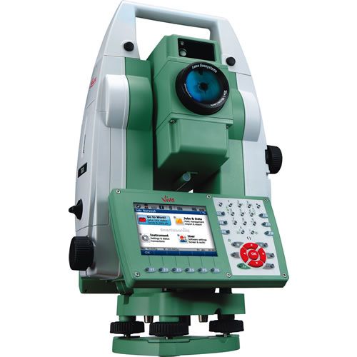

Leica Viva TS11 Manual Total Station
Leica Viva TS11, is the most advanced manual total station with the inclusion of Leica SmartWorx Viva easy-to-use onboard software, imaging and GNSS capability
$0.01
Availability:
Out of stock
SKU
XPTS20
Condition: Refurbished
Warranty: 1 YEAR WARRANTY
Shipping: USA & Worldwide
Request a Quote for
* Leica Viva TS11 Manual Total Station
Leica Viva TS11 Manual Total Station
Leica Viva TS11, is the most advanced manual total station with the inclusion of Leica SmartWorx Viva easy-to-use onboard software, imaging and GNSS capability. With a complete package of easy-to-use software your work can start immediately and be finished faster than ever before. Add full GNSS functionality to your Viva TS11 whenever you want and combine TPS and GNSS in the most efficient way. Or use imaging with the unique capture-sketch-link functionality. High resolution total station images can be captured, enhanced with sketching and then linked to any point of interest. Costly revisits can be avoided to significantly improve productivity. Every vision on every scale becomes reality with ease.
Simply productive surveying software
With clear graphics, non-technical terminology and simplified workflows SmartWorx Viva is incredibly easy to use.
With PinPoint EDM, Viva TPS delivers the optimal balance of range, accuracy, reliability, beam visibility, laser dot size and measurement time.
Add full GNSS functionality to your Viva TS11 whenever you want and combine TPS and GNSS in the most efficient way.
Specifications:
Leica Viva TS11, is the most advanced manual total station with the inclusion of Leica SmartWorx Viva easy-to-use onboard software, imaging and GNSS capability. With a complete package of easy-to-use software your work can start immediately and be finished faster than ever before. Add full GNSS functionality to your Viva TS11 whenever you want and combine TPS and GNSS in the most efficient way. Or use imaging with the unique capture-sketch-link functionality. High resolution total station images can be captured, enhanced with sketching and then linked to any point of interest. Costly revisits can be avoided to significantly improve productivity. Every vision on every scale becomes reality with ease.
Simply productive surveying software
With clear graphics, non-technical terminology and simplified workflows SmartWorx Viva is incredibly easy to use.
- Survey, coding and lineworks
- Including full application package
With PinPoint EDM, Viva TPS delivers the optimal balance of range, accuracy, reliability, beam visibility, laser dot size and measurement time.
- 1 mm + 1.5 ppm to prism
- 2 mm + 2 ppm to any surface
- 1000 m range without a prism
Add full GNSS functionality to your Viva TS11 whenever you want and combine TPS and GNSS in the most efficient way.
- Use SmartStation for TPS setup without the need of control points, traverses and resections
Specifications:
| Angle Measurement (Hz, V) |
|
| Accuracy |
1” (0.3 mgon) / 2” (0.6 mgon) / 3” (1 mgon) / 5” (1.5 mgon) |
| Method |
Absolute, continuous,
diametrical: at all models |
| Display resolution |
0.1” / 0.1 mgon |
| Compensation |
Quadruple Axis compensation: at all models |
| Compensator Setting Accuracy |
0.5”/0.5”/1”/1.5" |
| Distance Measurement with Reflector | |
| Range Round prism (Leica GPR1) |
3.500 m |
| Range Reflective tape (60 mm x
60 mm) |
250 m |
| Accuracy |
Standard: 1.0 mm + 1.5 ppm Fast: 2.0 mm + 1.5 ppm Tracking: 3.0 mm + 1.5 ppm |
| Typical Measurement time |
1.0 s |
| Distance Measurement without Reflector | |
| Range PinPoint R500 / R1000 |
> 500 m / > 1000 m (Optional) |
| Accuracy |
2 mm + 2 ppm |
| Laser dot size |
At 30 m: approx. 7 x 10 mm At 50 m: approx. 8 x 20 mm |
| Data storage / Communication | |
| Internal memory |
1 GB |
| USB memory stick |
1 GB
(Optional) |
| SD Card |
8 GB
(Optional) |
| Interfaces |
– Serial (Baudrate up to
115’200) – USB Type A and mini B, – Bluetooth® Wireless, class 1 – Bluetooth® > 1000 m (with TCPS29) |
| Data formats |
Custom ASCII, DXF, LandXML, FBK, RW5, RAW |
| Guide Light (EGL) | |
| Working Range (average atmospheric conditions) |
5 m – 150 m |
| Positioning accuracy |
5 cm at 100 m |
| Telescope |
|
| Magnification |
30 x |
| Resolving power |
3" |
| Field of View |
1° 30’ (1.66 gon) 2.7 m at 100 m |
| Focusing range |
1.7 m to infinity |
| Reticle |
Illuminated, 10 brightness levels |
| Keyboard and Display | |
| Display |
High resolution Color &
Touch display, 65’000 colors, graphics, Full-VGA, display illumination, 10 brightness levels |
| Keyboard |
36 keys, (12 function keys, 12 alphanumerical keys), illumination |
| Position |
Face I, Face
II (Optional) |
| Operating System | |
| Windows CE |
6.0 |
| Laserplummet |
|
| Type |
Laser point, 5 brightness levels |
| Centering accuracy |
1.5 mm at 1.5 m Instrument height |
| Internal Battery | |
| Type |
Lithium-Ion |
| Operating time |
approx. 14 hours |
| Weight |
|
| Total station including GEB222
and tribrach |
5.8 kg |
| Environmental |
|
| Temperature range (operation) |
–20° C to +50° C (–4° F to +122°
F) Arctic Version –35° C to 50° C (–31° F to +122° F) (Optional) |
| Dust / Water (IEC 60529) Humidity |
IP55, 95%, non condensing |
| Leica SmartWorx Viva Onboard Software | |
| Included Application Programs |
Survey & Coding with
Lineworks Stakeout DTM Stakeout Station Setup Surface & Volumes Remote Height Hidden Point Offset Reference Line / Arc Cogo Traverse Sets of Angles Determine Coordinate Systems |