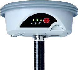


Leica GS09 GNSS RTK SmartAntenna
The SmartAntenna can be used in a large variety of operating modes, providing you with a complete surveying system.
$0.01
Availability:
Out of stock
SKU
XPGS09
Condition: Refurbished
Warranty: 1 YEAR WARRANTY
Shipping: USA & Worldwide
Request a Quote for
* Leica GS09 GNSS RTK SmartAntenna
Leica GS09 SmartAntenna
The SmartAntenna can be used in a large variety of operating modes, providing you with a complete surveying system.
Features:
- RTK Rover – exceptionally rugged and light weight pole setup without any cables
- Reference Station – easily setup RTK base station operates without controller
- Network Rover – a complete surveying system, operating in all reference networks
- SmartStation – the GS09 fits onto a TPS creating one easy-to-use instrument
Specifications:
| Measurement Engine | |
| Leica patented SmartTrack+ technology | • Jamming resistant measurements • High precision pulse aperture multipath correlator • Excellent low elevation tracking technology • Very low noise GNSS carrier phase measurements with <0.5 mm precision • Minimum acquisition time |
| No. of channels | 72 channels |
| Reacquisition time | <1 sec |
| GNSS Measurements | |
| Satellite signals tracking | GPS: L1, L2, L2C (C/A, P, C Code) GLONASS: L1, L2 (C/A, P narrow Code) |
| Accuracy | |
| DGPS/RTCM | Typically 25 cm (rms) |
| RTK Rapid static (phase) Static mode after initialization |
Horizontal: 5 mm + 0.5 ppm (rms) Vertical: 10 mm + 0.5 ppm (rms) |
| RTK Kinematic (phase) Moving mode after initialization |
Horizontal: 10 mm + 1 ppm (rms) Vertical: 20 mm + 1 ppm (rms) |
| Post Processing (phase) Static with long observations |
Horizontal: 3 mm + 0.5 ppm (rms) Vertical: 6 mm + 0.5 ppm (rms) |
| Post Processing (phase) Rapid static mode |
Horizontal: 5 mm + 0.5 ppm (rms) Vertical: 10 mm + 0.5 ppm (rms) |
| On-The-Fly initialization | |
| Reliability | Better than 99,99% using Leica SmartCheck+ technology |
| Time for initalization | Typically 8 sec |
| RTK baseline range | up to 50 km |
| User Interface | |
| Keys | On / Off key |
| Led Status indicator | Satellite tracking, Bluetooth® communication and battery power |
| Communication ports | • Combined USB / Power port with 8-pin Lemo plug • Integrated Bluetooth® port • 5-pin clip on contacts for Leica SmartStation setup |
| Physical | |
| Weight | 1.05 kg including battery |
| Dimension (diameter x height) | 186 mm x 89 mm |
| Environmental specifications | |
| Temperature, operating | -40° C to +65° C (-40° F to +149° F) |
| Temperature, storage | -40° C to +80° C (-40° F to +176° F) |
| Humidity | 100% |
| Sealed against water | IP67: Temporary submersion into water (max. depth 1 m) |
| Sealed against sand and dust | Dust tight, protection against blowing dust |
| Vibration | Withstands vibrations in compliance with ISO9022-36-08 |
| Drops | Withstands 1 m drop onto hard surface |
| Topple over | Withstands topple over from a 2 m survey pole onto hard surface |
| Functional shock | No loss of lock to satellite signals when used on a pole setup and submitted to pole bumps up to 150 mm |
| Power management | |
| Supply Voltage | Nominal 12 V DC, Range 10.5 – 28 V DC |
| Power consumption | Typically: 1.8 W, 150 mA |
| Internal Power supply | Removable & rechargable Li-Ion battery, GEB211 2.2 Ah / 7.4 V or GEB212 2.6 Ah / 7.4 V |
| Operation time | Up to 7 hours using GEB212 battery |
| RTK transmission | |
| Source | Direct from GS09 (No datalogger required) |
| RTK format | Leica Lite propriety format |
| Radio Modems | All Satelline and Pacific Crest radios in GFU or standard housing |
| Integration with TPS | |
| SmartStation functionality | Connects to Leica TPS1200, TS30 and TM30 instruments |
| Manufacturer | Leica |
|---|