
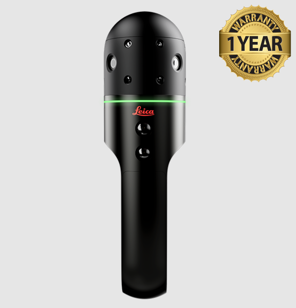


Leica BLK2GO Pulse Handheld Imaging Laser Scanner
Condition: Refurbished
Warranty: 1 YEAR WARRANTY
Shipping: USA & Worldwide
* Leica BLK2GO Pulse Handheld Imaging Laser Scanner[ID-L/T*]
* Battery Charger
* Carrying Case
Leica BLK2GO Pulse Handheld Imaging Laser Scanner
The Leica BLK2GO PULSE is a handheld first-person laser scanner. Instantly capture what you need, when you need it, from your point of view. Using new, advanced reality capture technology, the BLK2GO PULSE delivers complete, colorized point clouds to your smartphone while you scan with no post-processing required. Used in combination with the BLK Live app, the BLK2GO PULSE fuses Leica Geosystems’ proven GrandSLAM technology with dual solid-state Time-of-Flight (ToF) LiDAR sensors to deliver a complete reality capture solution.
Key Features:
- First-person scanning: See what you capture from a first-person scanning perspective. Colourised 3D data is streamed in real time to your smartphone screen.
- Instant data availability: Immediately view and share colorized 3D point clouds and images from the field, as easy as sharing a photo or video.
- Intuitive BLK Live companion app: With a smartphone (iOS or Android) attached to the scanner, access a streamlined end-to-end reality capture workflow in the BLK Live app.
- Smart scanning guidance: In-app notifications provide real-time guidance to ensure optimal scanning practices.
- Upload to Reality Cloud Studio, powered by HxDR: Easily upload scans from the field to Reality Cloud Studio, Hexagon’s cloud-based digital reality application for automated registration and meshing, immersive visualization, collaboration, and secure data sharing and storage.
| Housing | Black anodized aluminium |
| Real time registration | Height: 282 mm Diameter: 80mm |
| Weight | 750 g (850 g incl. battery) |
| Stand-alone operation | One-button operation |
| Mobile devices | BLK2GO Live app for iOS and Android including: live 2D and 3D while scanning, device status and data management. • Live 2D and colorized 3D view • Colorized first-person view while and after scanning • Smart sensor feedback & guidance • Device status & remote control • Data export: .e57, .jpg, .csv • Direct data upload to Reality Cloud Studio, powered by HxDR |
| Communication | Wireless (app connection) |
| Internal memory | 40 hours of scanning (compressed data) 20 hours of scanning (uncompressed data) |
| Laser class | 1 (in accordance with IEC 60825-1:2014) |
| No. of LIDAR sensors | 2 |
| Wavelength | 940 nm Invisible |
| Field of view | 210° (horizontal) / 85° (vertical) |
| Spatial Resolution | 7,816 laser spots |
| Range | min. 0.5 m - up to 10 m |
| Point measurement rate | 420,000 pts/sec |
| Camera system | 12 Mpixel, 90° x 120°, rolling shutter |
| Panoramic vision system | 3-camera system, 4.8 Mpixel 300° x 135°, global shutter |
| Range noise | Real-time: +/- 15 mm Post-processed: +/- 5 mm |
| Accuracy indoor | +/-2 mm |
| Data transfer | Wireless and USB 3.0 |
| Desktop software | Leica Cyclone REGISTER 360 and Cyclone REGISTER 360 (BLK Edition) |